









Summary
Parque Las Palmas, Mojoneras and Los Tamarindos in Ixtapa are the Puerto Vallarta neighborhoods with the strongest recent flood record: together they took about 80% of the 1,260 homes hit by the October 2025 storm.
Add Villas Universidad, with 132 homes, and four areas account for more than 90% of the damage. Most of the city didn't flood badly; a few drainage corridors did.
So far, the 2026 rainy season has been quieter. A flood in August 2026 affected at least 18 homes, but the new trouble spots are sewers and drains: 2 failed pumps at the PTAR Norte I plant contributed to sewage backing up in Versalles in October 2026.
Parque Las Palmas tops the list with 394 affected homes, almost a third of the total, after an arroyo draining toward Estero El Salado overflowed and put about one meter of water inside some homes.
Mojoneras had 320 homes, 83 businesses and three schools hit in the same storm, and it flooded again in another storm that same rainy season.
Ixtapa is too big to judge by name. Los Tamarindos had 298 affected homes, while other parts of Ixtapa sit on different ground and drainage paths.
Portales only had 40 homes in the 2025 count, but the same bottleneck around Calle Quimixto keeps needing pumps year after year, and Jardines del Puerto residents are still complaining about water piling up on their side of the channel.
Gaviotas, La Floresta, Las Juntas, Bobadilla and El Calvario all appear among the 12 river or channel overflow points on the city's current Protección Civil map. Bobadilla (22 homes) and El Calvario (20) also flooded in 2025.
The beach areas are not the worst. Most of the 1,260 damaged homes were inland; the Hotel Zone and Palmar de Aramara mostly get street, garage and access flooding.
Riverside lots are a different risk. After Hurricane Lidia in 2023, the Río Pitillal ate the ground under a three-story house in San Esteban, and about 300 meters of drainage along the Río Cuale needed repair.
Hillside areas like Amapas and Conchas Chinas hold less water but swap it for runoff, rockfall and retaining-wall problems, as landslides along Highway 200 south of the city keep showing.
A new condo can keep its units dry and still lose its garage, pumps and elevators. Insurance for a condo with around USD 300,000 of cover runs about USD 600 to 900 a year, but read the flood exclusions and the named-storm deductible.
Bottom line: use the neighborhood name as a first filter only. The exact street, floor height, nearest arroyo or river, basement and access road tell you far more than the colonia on the listing.

Which neighborhoods took most of the October 2025 flood damage?
Parque Las Palmas, Mojoneras and Los Tamarindos in Ixtapa have the strongest recent evidence of large-scale residential flooding in Puerto Vallarta.
After the October 2025 storm, one of the worst rain events in years, the official count reached 1,260 affected homes across the municipality. Parque Las Palmas accounted for 394, Mojoneras for 320 and Los Tamarindos for 298. Villas Universidad followed with 132.
Those numbers are unusually concentrated. The three hardest-hit areas represented about 80% of all affected homes, while adding Villas Universidad takes the share above 90%. There was damage all over the city, but most of it piled up in a handful of places. Some local reports give slightly different neighborhood subtotals, but the ranking stays the same.
The type of flooding also matters. In Parque Las Palmas, an arroyo connected to the drainage system toward Estero El Salado overflowed, with local reporting describing water around one meter deep inside some homes. Mojoneras suffered residential, commercial and school damage. Los Tamarindos showed that serious flooding can occur well inland in Ixtapa rather than along the tourist beachfront.
| Area | Homes affected | Share of 1,260 homes | What happened | Current concern |
|---|---|---|---|---|
| Parque Las Palmas | 394 | 31.3% | Arroyo overflow | Very high |
| Mojoneras | 320 | 25.4% | Heavy runoff and channel flooding | Very high |
| Los Tamarindos, Ixtapa | 298 | 23.7% | Residential flooding | Very high |
| Villas Universidad | 132 | 10.5% | Residential flooding | High |
| Portales | 40 | 3.2% | Recurring drainage problems | High locally |
| Vallarta 500 | 32 | 2.5% | Residential flooding | Localized |
| Bobadilla | 22 | 1.7% | Flooding plus current official risk mapping | High locally |
| El Calvario | 20 | 1.6% | Flooding plus current official risk mapping | High locally |
Is flooding spread across Puerto Vallarta or concentrated in a few areas?
Puerto Vallarta's serious flood damage is much more concentrated than the city's rainy-season reputation suggests.
Puerto Vallarta sits between steep mountains and Banderas Bay, so heavy rain comes down through rivers, arroyos and drainage channels before reaching lower ground. That creates very different conditions within a few kilometers.
The city's Protección Civil work makes the pattern clear. Its latest mapping identifies 12 river or channel overflow points, alongside many road sections where flooding repeatedly becomes dangerous. Named locations include Las Juntas, El Calvario, Bobadilla, Gaviotas, La Floresta and several inland crossings.
That is why two properties at similar elevations can behave completely differently. One may sit directly downstream from an arroyo while another drains normally. A third may remain dry but lose its only vehicle access.
The better way to read Puerto Vallarta is by drainage corridor, not as one big flood zone.
Has the 2026 rainy season changed the picture?
Not much. No neighborhood-by-neighborhood count for 2026 has been published, and nothing so far comes close to the 1,260 homes of October 2025.
The biggest 2026 event we found was a flood in August that affected at least 18 homes, according to local reports citing Protección Civil. Those reports don't pin the damage to a specific neighborhood, so we don't either.
The new problem is less about rivers and more about pipes. In early October 2026, SEAPAL, the city's water utility, said 2 failed pumps at its PTAR Norte I treatment plant contributed to sewage backing up into the streets of Versalles during heavy rain. It also reported drainage work near Las Glorias, where high tides and rain together slow how fast water can leave the streets.
If you're looking in Versalles, ask the seller and the neighbors what happened on that street this October, and whether sewage came up through the drains.
So the 2025 ranking still holds. A quieter year doesn't mean the arroyos in Parque Las Palmas or Mojoneras got fixed; it mostly means 2026 didn't bring a storm like October 2025.
Is Parque Las Palmas one of Puerto Vallarta's worst flood areas?
Yes. Parque Las Palmas belongs at the top of any Puerto Vallarta flood-risk shortlist.
The strongest evidence is the scale of the damage there. The neighborhood recorded 394 affected homes in October 2025, more than any other named area. That alone represented almost one-third of all the damaged homes reported across the municipality.
The mechanism makes the episode harder to dismiss as a freak blocked drain. An arroyo that ultimately drains toward Estero El Salado overflowed, sending water rapidly into the neighborhood. Contemporary reports described water reaching roughly one meter inside some properties.
If you're looking at Parque Las Palmas, start with flooding. Check how high the finished floor sits above the road, how close the parcel is to the arroyo, where runoff goes, and what happened to that exact building during the last major event.
How bad is flooding in Mojoneras?
Mojoneras has a serious enough flood history that water risk should be part of the neighborhood's basic property due diligence.
Around 320 homes were affected in October 2025, along with 83 commercial premises, three schools and a church. That broader damage footprint is useful because it shows water was reaching much more than one isolated residential block.
Mojoneras also flooded badly in another storm during the same rainy season, with public aid later directed toward affected families and schools. Two bad floods in one season is a pattern, not bad luck.
Road access adds another weakness. Avenida México around the Mojoneras entrance has accumulated dangerous amounts of water during heavy rain, so a property can remain physically dry while residents still struggle to get in or out.
Does Ixtapa flood?
Yes, parts of Ixtapa flood badly, but the Ixtapa label is far too broad to tell a buyer whether a particular property is exposed.
Los Tamarindos is the clearest warning. It had 298 affected homes in October 2025, putting it among the hardest-hit areas anywhere in Puerto Vallarta.
Other Ixtapa corridors have different problems. Protección Civil has identified dangerous water movement around José Guadalupe Zuno, while roads crossing natural drainage routes can carry fast runoff, mud and debris from higher ground.
The older planning record already pointed in the same direction. Development around Ixtapa and Las Juntas expanded over relatively flat terrain associated with the Ameca drainage system, where water naturally has fewer places to escape quickly.
We would never approve or reject an Ixtapa property from the neighborhood name alone. Los Tamarindos deserves much more suspicion than many other parts of the delegation, and a street close to a natural runoff route deserves more suspicion than a higher parcel nearby.
| Ixtapa-area issue | Evidence | What it means | What to check |
|---|---|---|---|
| Los Tamarindos | 298 affected homes | Proven severe residential flooding | Exact building history |
| José Guadalupe Zuno area | Current official overflow mapping | Water can move dangerously through the corridor | Distance from channel |
| Ameca-side flat terrain | Longstanding planning concern | Flood exposure is partly geographic | Parcel elevation |
| Natural runoff routes | Mud and debris during heavy storms | Water may move fast rather than simply pool | Upstream terrain |
| Main road crossings | Roads can flood separately from homes | Access can fail | Alternative route |
Is Portales still one of Puerto Vallarta's flood-prone neighborhoods?
Yes. Portales looks more worrying than its 2025 flood count suggests, because the same drainage problem keeps coming back.
Only 40 Portales homes appeared in the October 2025 damage count, far below Parque Las Palmas or Mojoneras. Looking over several years gives a different picture.
Calle Quimixto has repeatedly accumulated enough water for authorities to deploy pumps, clear clogged grates and prevent water from entering nearby houses. Older reporting already described the Portales area as one of the places where this intervention was needed year after year.
The El Contentillo drainage corridor ties Portales to nearby Los Patos and Jardines del Puerto, and debris or restricted flow has repeatedly made that system harder to drain during intense rain.
Portales is a good example of why one storm ranking can mislead. It may not produce the biggest citywide damage number every time, but repeated trouble around the same streets is exactly what a property buyer should take seriously.
Does Jardines del Puerto flood too?
Yes. Flooding around Jardines del Puerto is still a live issue, particularly near Calle Quimixto and the drainage channel beside Portales.
Residents raised the problem again recently, saying that changes around a bridge had altered how stormwater moved through the area. Water was reportedly accumulating on the Jardines del Puerto side while draining more effectively elsewhere along the same channel.
This is useful evidence because it is current and extremely local. We are looking at how one piece of infrastructure can change water behavior over a few hundred meters, not whether an entire colonia has some distant flood history.
The same corridor already had a history of pumping and drainage intervention. Fresh complaints around it strengthen the case that this remains an unresolved property-level issue rather than an old reputation that has outlived the problem.
Anyone buying around Quimixto should inspect the street during heavy rain if possible, or at minimum speak with several residents who have actually lived through recent rainy seasons.
Does Gaviotas flood?
Yes, parts of Gaviotas have a real flood problem, especially around the neighborhood's drainage channels and lower streets.
Gaviotas has previously seen channel overflow during heavy rain, with mud entering properties as water moved toward the Arroyo Los Camarones system. Nearby Palmar de Aramara suffered house flooding during the same broader storm conditions.
Gaviotas also appears in Puerto Vallarta's current official list of river and channel overflow points. Calle Gaviotas has separately been associated with recurring road flooding.
That combination makes Gaviotas a convincing localized hotspot. The evidence comes from actual incidents and the city's latest risk work.
Pay particular attention to ground-floor units, below-grade parking and properties close to the channel. A few streets of separation can make a large difference here.
Do Palmar de Aramara and the Hotel Zone flood?
Parts of Palmar de Aramara and the Hotel Zone do flood, although the more common problem is street and drainage flooding rather than hundreds of homes going underwater at once.
Palmar de Aramara has a documented history of water entering homes after drainage became obstructed around streets such as Montessori and Océano Índico.
Avenida Francisco Medina Ascencio also accumulates water during strong storms. That matters because it is the main north-south artery through much of the Hotel Zone. Sections around Politécnico and the IMSS area have appeared among recurrent trouble spots.
For condo buyers, the weak point may sit several floors below the apartment. Underground parking, elevator systems, pumps, electrical equipment and entrance ramps can all fail before water comes anywhere near an upper-floor unit.
The access road deserves the same attention. A dry tower with a flooded driveway or an impassable section of Medina Ascencio can still become a major nuisance during a storm.
Which Puerto Vallarta neighborhoods face Río Pitillal flooding?
San Esteban and several communities beside the Río Pitillal deserve serious scrutiny because the river can erode land beneath properties, not merely put water across the road.
After Hurricane Lidia in October 2023, the Río Pitillal ate away parts of the bank in San Esteban. One three-story house lost so much ground beneath it that the property became uninhabitable, while other riverside homes were also threatened.
That history follows earlier damage along the same corridor. Municipal prevention work has covered communities including San Esteban, Independencia, Cristóbal Colón, Ex Haciendas del Pitillal and other homes close to the river.
A buyer should treat proximity to the active riverbank very differently from ordinary rainy-season street flooding. Fast water can remove soil, damage retaining structures and undermine a foundation even when the main living area stays above the water.
The safe distance also cannot be judged from a map pin alone. Bank shape, retaining work, elevation and the river's position relative to the lot all need to be checked on site.
| Pitillal-area location | Evidence | Main concern | Buyer check |
|---|---|---|---|
| San Esteban | Homes undermined after major river rise | Bank erosion | Distance from riverbank |
| Ex Haciendas del Pitillal | Preventive risk work | Flood and erosion | Bank protection |
| Independencia | River-corridor monitoring | High water | Parcel position |
| Cristóbal Colón | Preventive inspections | River exposure | Elevation and access |
| Other riverside Pitillal properties | Repeated storm concern | Fast current | Retaining walls and foundations |

Does the Río Cuale make Zona Romántica flood-prone?
The immediate Río Cuale corridor can be dangerous, but most of Zona Romántica should not be treated as if it shares the same flood exposure.
The difference becomes obvious when we look at actual events. During Hurricane Nora in August 2021, the Cuale rose violently enough to damage bridges, riverfront infrastructure and buildings around central Puerto Vallarta. One building beside the river collapsed, and the force of the water caused major destruction around the Insurgentes crossing and the Cuale market area.
Earlier flooding had already pushed water into homes and businesses around streets such as Aquiles Serdán, Constitución and 5 de Febrero in Emiliano Zapata. Water reportedly reached around one meter in parts of that river-adjacent area during one episode.
The risk does not disappear after the water drops. Subsequent hurricanes have eroded stretches of the Cuale bank around El Cerro and Gringo Gulch, damaging retaining walls and drainage infrastructure. After Lidia, roughly 300 meters of drainage infrastructure along the river required repair.
So a riverside unit around the Cuale deserves real caution. A property several blocks away and higher into Emiliano Zapata can have a completely different profile despite carrying the same broad neighborhood label.
Does Centro flood?
Lower parts of Puerto Vallarta Centro can flood, especially around the Río Cuale and streets receiving runoff from higher terrain.
The clearest historical damage sits near the river. Cuale flooding has hit the southern side of Centro, bridges and adjoining infrastructure during major storms, while strong rain can also overwhelm older street drainage.
Moving uphill changes the picture quickly. El Cerro and higher Centro generally shed water rather than hold it, although steep runoff, erosion and retaining-wall issues become more relevant there.
That makes "Centro" almost useless as a standalone flood answer. A lower river-adjacent property and a hillside property a few blocks away may share a postal neighborhood while facing almost opposite water problems.
For a buyer, we would want the exact street before making any meaningful judgment.
Do Las Juntas and the Ameca River area flood?
Yes. Las Juntas and the flatter Ameca River corridor have a genuine floodplain problem that has been recognized in Puerto Vallarta's planning documents for years.
The Río Ameca drains a much larger watershed than the small urban channels running through central Puerto Vallarta. Water levels can therefore respond to heavy rainfall occurring well beyond the immediate neighborhood.
The river has overflowed onto land around Las Juntas before, and Puerto Vallarta's current Protección Civil work again identifies Las Juntas around Rubí and Lázaro Cárdenas as one of its river or channel overflow points.
Older municipal planning also flagged the expansion of urban development over relatively flat, naturally inundable terrain around the Ameca outlet, particularly toward Las Juntas and Ixtapa.
For property buyers, that longer history is useful. Las Juntas is not appearing today because of one freak event; the underlying geography has been known for much longer.
Does La Floresta flood?
Yes, La Floresta has enough current and historical evidence to deserve flood scrutiny, particularly where roads cross fast runoff.
La Floresta appears on Puerto Vallarta's latest official list of river and channel overflow points, alongside a separate location around Calle Obelisco in the same area.
Past storms have also stranded vehicles around La Floresta, and one recent major event became fatal when a vehicle was swept away by the current nearby.
A simple flood-depth map misses part of the danger here. In La Floresta, moving water across streets may be just as important as water entering houses.
Investigate the route to the property as carefully as the property itself. If the only practical access crosses one of these runoff paths, living there can become difficult during the strongest storms even when the house remains dry.
What about Bobadilla, El Calvario and Vallarta 500?
Bobadilla and El Calvario worry us more than Vallarta 500, because the city's current overflow map backs up their recent flood history.
Bobadilla and El Calvario both appeared in the October 2025 damage count, with 22 and 20 affected homes respectively. Those numbers were modest compared with the hardest-hit neighborhoods.
The more interesting development is what happened afterward. Puerto Vallarta's latest Protección Civil map again identifies both Bobadilla and El Calvario among its river or channel overflow points.
That recurrence adds weight. Vallarta 500 recorded 32 affected homes in the same large storm, but the evidence we found is less persistent across separate events and current risk mapping.
Bobadilla and El Calvario therefore go into the automatic "check the exact street and drainage channel" category. Vallarta 500 still needs investigation, but we would place less confidence in calling the entire neighborhood a recurring hotspot.
Are Puerto Vallarta's hillside neighborhoods safer from flooding?
Higher neighborhoods such as much of Amapas, Conchas Chinas and elevated Centro generally face less standing-water flood risk, although buyers trade that for runoff, erosion and slope problems.
Water moves off steep terrain quickly, which reduces the broad ponding seen in flatter inland neighborhoods. That is one reason the largest recent residential flood counts came from places such as Parque Las Palmas, Mojoneras and Ixtapa rather than upper Amapas or Conchas Chinas.
On the hills, heavy rain can loosen soil, move rocks, overload retaining walls and block access roads. Puerto Vallarta has repeatedly dealt with landslides and rockfalls along steep urban roads and Highway 200 south of the city.
Building quality becomes extremely important. A properly engineered hillside condo with strong retaining structures may be an excellent way to reduce flood exposure. A poorly supported property on a steep slope can simply exchange one risk for another.
For buyers whose main concern is water entering the home, elevation generally helps. It should never be the only safety test.
Can a new Puerto Vallarta condo still have flood problems?
Yes. A newer Puerto Vallarta condo can keep apartments dry and still suffer expensive flood damage downstairs or outside the property.
Basement parking is the obvious weak point. Water entering a garage can damage cars, elevators, pumps and electrical equipment long before it threatens an apartment several floors above.
Entrance design matters too. A ramp descending from a flooded road effectively funnels water toward the building unless drainage and pumping have been designed for extreme rainfall.
Then there is access. Puerto Vallarta has multiple roads that repeatedly become flooded or dangerous during storms, so residents can temporarily lose practical access even when the building itself performs well.
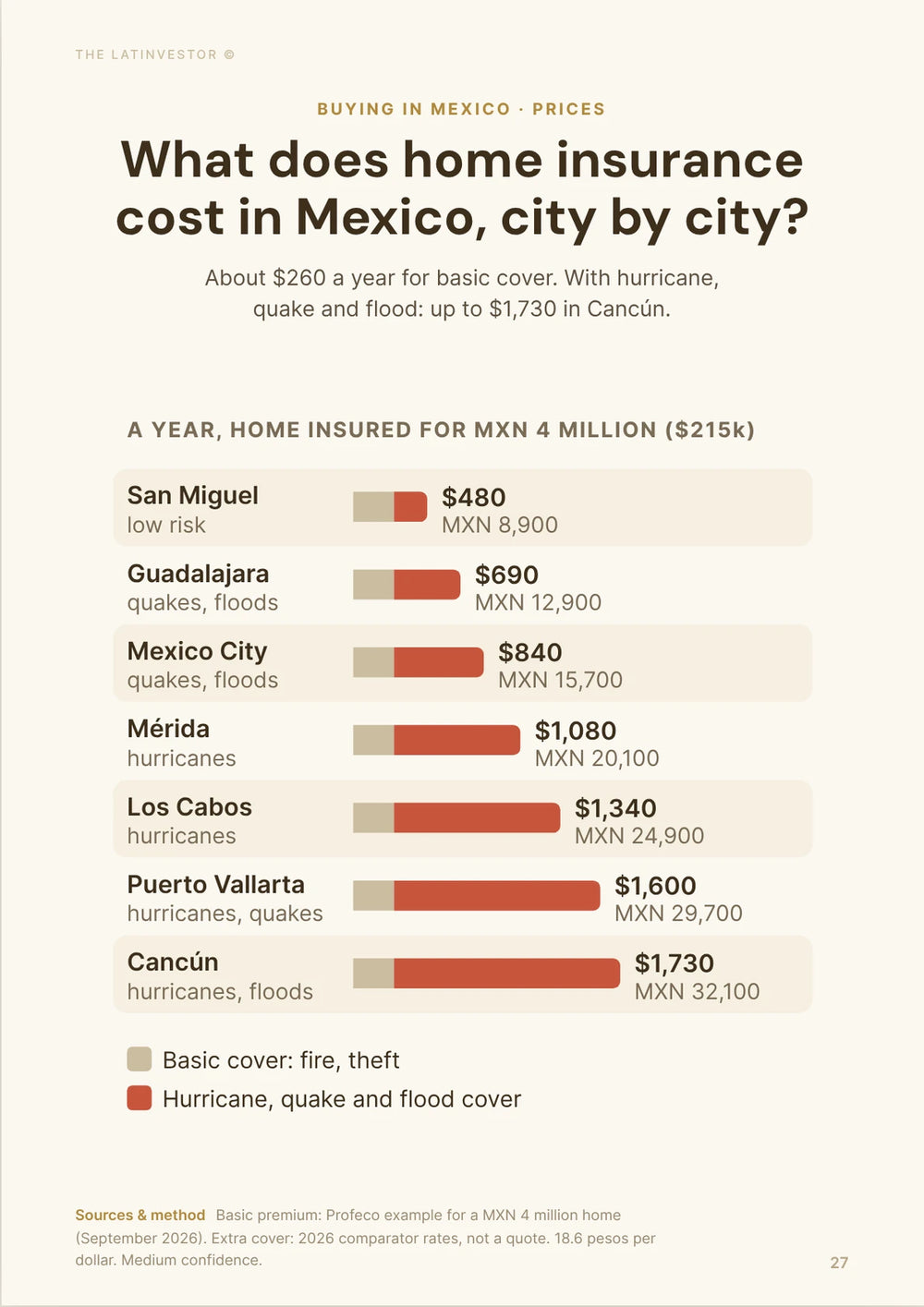
Don't count on insurance to fix all of it. Guides for foreign owners put a typical condo premium at about USD 600 to 900 a year (MXN 11,200 to 16,700) for around USD 300,000 of cover with hurricane exposure. The price is the easy part: check the named-storm deductible, whether flood is excluded, and what the building's own master policy actually covers for the garage and shared equipment.
When inspecting a condo, split the question into three parts: can water reach the unit, can water disable the building, and can residents still reach the property? The answers are often different.
Can you judge Puerto Vallarta flood risk from the neighborhood name?
No. Puerto Vallarta flood risk becomes much more accurate once we get down to the street, parcel and building.
Portales and Jardines del Puerto show why. A recurring problem around Calle Quimixto can affect properties close to the drainage bottleneck much more severely than other homes carrying the same neighborhood name.
The Cuale corridor gives an even clearer example. A low riverside building in Emiliano Zapata can face major flood and erosion exposure while another property farther uphill sits in a very different physical position.
Ixtapa is broader still. Los Tamarindos has proven residential flood exposure, yet that tells us almost nothing about a property several kilometers away elsewhere in Ixtapa.
Use the neighborhood as a first filter. The street, elevation, nearest channel, distance from the river, basement layout and access route usually tell you more.
| Level | What it tells us | What it misses | How useful it is |
|---|---|---|---|
| Puerto Vallarta overall | General rainy-season exposure | Local drainage | Low |
| Neighborhood | Broad hotspot screening | Street differences | Moderate |
| Street | Drainage and access pattern | Building resilience | High |
| Parcel | Elevation and channel proximity | Internal systems | Very high |
| Building | Garage, pumps, elevators, electrical risk | External access | Very high |
| Access route | Whether residents can get in and out | Interior damage | High |


What should buyers check before buying in a Puerto Vallarta flood area?
The best flood question for a Puerto Vallarta property is: "What happened on this exact street during the worst recent storms?"
Asking only whether the unit has flooded leaves too much room for a technically true but useless answer. A seventh-floor condo may never have taken water while the garage flooded, the elevator stopped working and the entrance road became impassable.
Ask the building manager and several long-term residents what happened during Puerto Vallarta's strongest recent storms. Photos are better than recollections. Maintenance records can reveal pump replacements, elevator repairs, electrical work or repeated water removal.
The physical inspection should then focus on water paths. Look at the difference in height between the entrance and the road, find the closest arroyo or channel, check whether parking goes underground and see where rainwater would move if the drains stopped working.
The Protección Civil overflow map is also worth checking because the city now identifies precise overflow points rather than relying only on broad neighborhood warnings.
If the property is close to a river, add bank erosion and foundation stability to the inspection. If it sits on a hillside, shift the focus toward retaining walls, slope drainage and road access.
So which Puerto Vallarta neighborhoods flood today?
The clearest Puerto Vallarta flood hotspots in 2026 are Parque Las Palmas, Mojoneras, Los Tamarindos and vulnerable parts of Ixtapa, with Portales, Jardines del Puerto, Bobadilla, El Calvario, Gaviotas and La Floresta also deserving serious address-level checks.
Riverfront properties create another tier of concern. Homes close to the Río Pitillal around San Esteban and other riverside communities can face erosion and structural damage. Around the Río Cuale, the most exposed properties are those immediately beside the river through Emiliano Zapata, Centro, Buenos Aires and nearby riverbank areas.
Las Juntas also deserves attention because of the Ameca floodplain and its long-recognized low-lying geography.
The useful distinction is severity. Parque Las Palmas, Mojoneras and Los Tamarindos produced the clearest recent concentration of flooded homes. Portales and Jardines del Puerto stand out for persistence around the same drainage corridor. Bobadilla, El Calvario, Gaviotas and La Floresta remain relevant because they still appear in the city's current overflow mapping. Versalles and Las Glorias are newer names to watch, more for sewage and drainage than for river flooding.
Higher parts of Amapas, Conchas Chinas and Centro generally look better if the sole concern is standing-water flooding, although hillside engineering then becomes more important.
Our take: Puerto Vallarta does have identifiable flood-prone neighborhoods, but buying decisions should quickly move below the neighborhood level. The evidence today is precise enough that a buyer can often narrow the real problem to a particular riverbank, channel, street or access route rather than treating an entire part of Puerto Vallarta as unsafe.
Our methodology
This article estimates which Puerto Vallarta neighborhoods flood the most and where that risk is really concentrated. We looked at documented damage, repeat incidents across separate storms, the city's current risk mapping, what physically causes the water, and how precisely each problem can be located.
The core numbers come from the official count after the October 2025 storm: 1,260 affected homes, with neighborhood totals for Parque Las Palmas, Mojoneras, Los Tamarindos, Villas Universidad and others. Local reports give slightly different subtotals for one or two areas; the ranking doesn't change. No neighborhood-level count for 2026 had been published when we checked, so 2026 events (18 homes in August, sewage backups in Versalles in October) are reported as they were, without being pinned to areas the sources didn't name.
We gave the most weight to recent evidence and to places where several independent signs line up: recent damage, repeat incidents, the current overflow map and the terrain. Older records (Hurricane Nora in 2021, Hurricane Lidia in 2023, past drainage works) are used to show that a corridor or floodplain problem has lasted, not to rank neighborhoods on their own.
We checked these figures in October 2026. The only amounts in the article are insurance costs, given in US dollars and converted at about 18.6 pesos per US dollar and 20.9 pesos per euro.
The limits: a damage count measures one storm, not the risk of every property in a neighborhood, and flood exposure can change over a few blocks. Insurance premiums are indicative ranges from buyer guides, not quotes. Treat this as a screening tool and check the exact street, parcel and building before buying.
Key sources used for this analysis include Vallarta Hoy's report on the 1,260 affected homes, DIF Jalisco's 2025 Puerto Vallarta damage assessment, Puerto Vallarta's 2025 emergency declaration, Puerto Vallarta Protección Civil's risk and weather portal, Quadratín Jalisco on the August 2026 flood, SEAPAL on the 2026 drainage backups, the Puerto Vallarta Municipal Risk Atlas, CONAGUA's Río Ameca flood-zone layer, CONAGUA's Lerma-Santiago-Pacífico regional water assessment, Puerto Vallarta's Portales flood-mitigation project, municipal documentation on La Virgen and El Contentillo drainage works, SEAPAL's post-Hurricane Nora infrastructure records, the federal emergency declaration for Hurricane Nora, NOAA's Hurricane Lidia report, Puerto Vallarta's Hurricane Lidia damage record, and Compass Abroad's homeowner insurance guide.